 What are Maps?
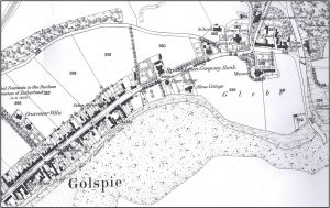
The Highland Archive Service holds a comprehensive set of maps: Ordnance Survey 1st and 2nd Series, Inland Revenue, National Grid and other Highland maps which have been deposited with us.
What dates do they cover?
- 1st Edition Ordnance Survey – 1843-1882 (6″) and 1855-1882 (25″).
- 2nd Edition Ordnance Survey – 1892-1907 (6″ and 25″).
- Inland Revenue – based on the 2nd Edition and marked to denote land/property ownership boundaries for the Finance Act 1910.
- National Grip – 1960s
- Other deposited – various dates
 What can I use them for?
- to see where an ancestor lived
- to learn how an area has changed or developed
- to locate a building
- to gain evidence in a boundary dispute
- to find features in the landscape which no longer exits
- to find sites of archaeological and historial importance
- to prove where a building once stood
What will they tell me?
Examining various series will reveal changes that have taken place over time. They will not usually give house numbers or owners’ names.
Will there definitely be useful information in there?
If you are keen to see where an ancestor lived the maps will give you useful contextual background. If you are tracing a building or boundary they will a vital source of information.
Are there any viewing restrictions?
No. All maps are open to view.
Can I request photocopies or take photographs?
It is possible to request photocopies or take photographs of Ordnance Survey, Inland Revenue and National Grid maps. Individual deposited maps may be subject to restrictions and staff will be able to advise. Copying charges apply.
Where can I find out what you hold?
Our collections are extensive and cover a large percentage of the Highlands. Follow the links below for more information.
- Highland Archive Centre, Inverness
- Lochaber Archive Centre, Fort William
- Skye and Lochalsh Archive Centre, Kyle of Lochalsh
- Caithness Archive Centre, Wick